If you build it, they will ride. That’s what the Baker-Polito Administration is hoping for with the addition of the Silver Line 3-Chelsea (SL3), newly opened last April. The SL3 offers an efficient one-seat connection to key destinations, including the Seaport and South Station, luring would-be car commuters and taking some of the strain off of five already overcrowded bus routes serving nearly 7,000 daily passengers in Revere and Chelsea. But while the SL3 grabbed headlines in Boston, locals celebrated an additional win in the form of the Chelsea Greenway, a new 0.65-mile shared-use path running parallel to the SL3 bus priority lane.
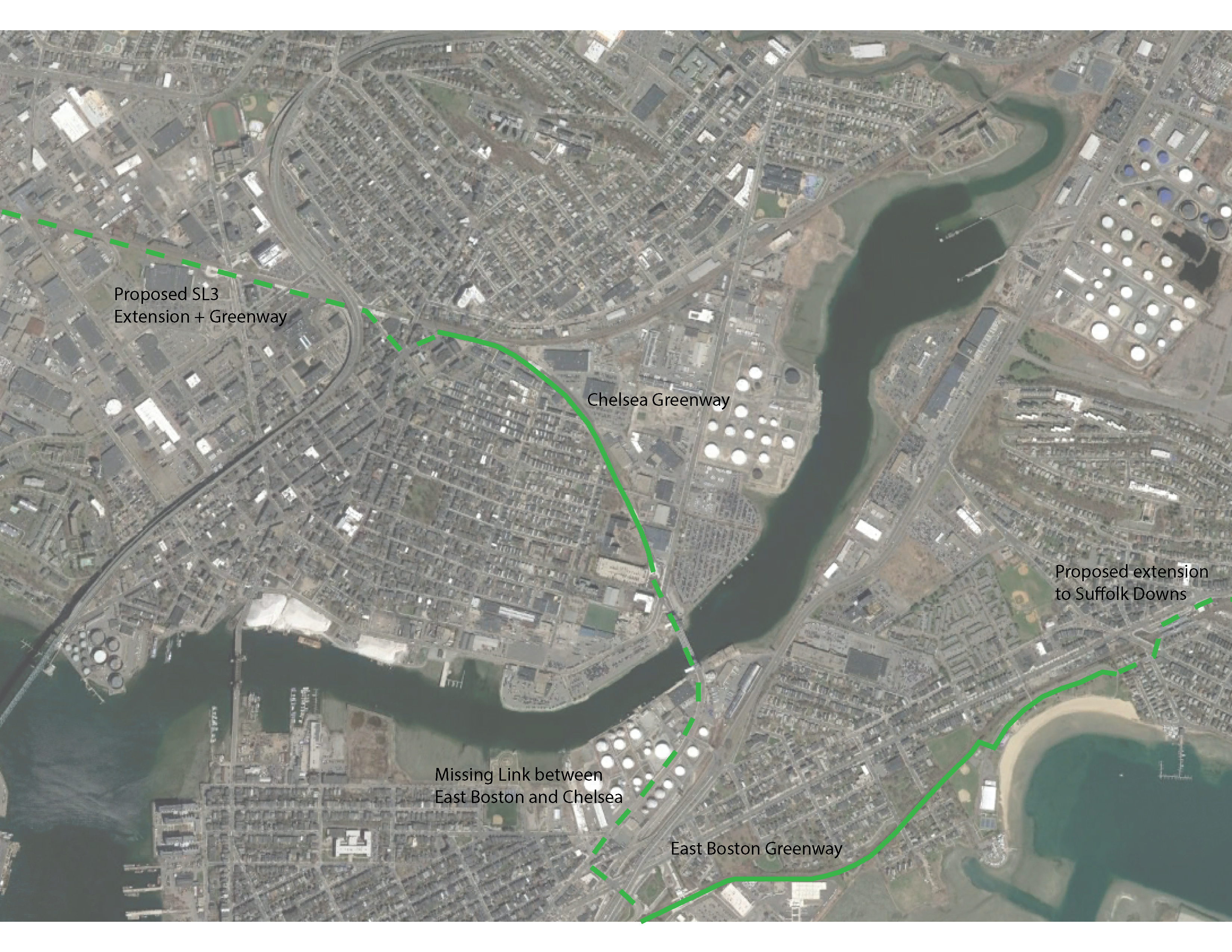 |
| Click image to enlarge. |
The Chelsea Greenway runs from Eastern Avenue along Chelsea Creek up to Chestnut Street, mere blocks from City Hall, Chelsea Public Library, and an abundance of shopping and eateries beginning in Bellingham Square. Originally constructed as part of the SL3 state project, the Chelsea Greenway will soon undergo notable enhancements overseen by the City of Chelsea. This work has been designed by Brown, Richardson, & Rowe Landscape Architects and generously funded through a grant of $1.1 million by the Executive Office of Energy and Environmental Affairs’ Gateway City Parks Program.
The Greenway path is an important extension of the larger transportation network, providing safer connections for people of all ages and abilities to walk or bike to transit, jobs, shop, and more. Although its current length may be less than a mile, the pathway is proof that the City of Chelsea is committed to increasing access and opportunity for its current residents, while planning for smart growth and development around the new transit options. In partnership with LivableStreets, the City is openly collaborating with surrounding communities to foster connectivity to the regional greenway network, including the Northern Strand Trail and the East Boston Greenway.
 |
| Photo: WalkBoston |
We’re excited to see the City extend this vision through several phases that will continue to build out connectivity and provide more active transportation options. Here’s a quick snapshot of what the City has planned:
- Transforming the numerous entrances to the Greenway into more welcoming plaza areas with new pavers, plantings, bike racks, and signage. These simple amenities will help attract more users to the greenway as a destination and place for activity and connection.
- Adding a diverse range of new trees, shrubs, and other plantings to improve air quality, the environment, and the quality of life of local residents.
- Introducing colorful and creative signage to help guide Greenway users.
- Extending connections to Everett Avenue and the local Market Basket through a safe on-road greenway connector, comprised of bike lanes, signage, and other streetscape improvements.
- Designing new open space along Chelsea Creek to provide an attractive destination at the eastern end of the Greenway.
- Through a joint effort between the City and their Bicycle and Pedestrian Committee, working on Complete Streets planning that includes building safe infrastructure for people biking and walking, providing network connections to the Greenway, as well as safe infrastructure to access the Chelsea Creek waterfront; ideally connecting existing open spaces at Mill Creek, Merritt Park, Highland Park, and P.O.R.T Park.
 |
| Photo: WalkBoston |
If you build it, they will thrive. Although it may be geographically small, the City of Chelsea, along with its partners and the Bicycle and Pedestrian Committee, is demonstrating what thoughtful planning can provide when it recognizes the need and benefits of providing safe and equitable options for connecting people and places. The City’s forethought to include a parallel greenway along with bus rapid transit is a winning combination that can serve as a model for other municipalities.
If you liked this post, consider reading more about greenway projects in this area: